ChartWorld and Raymarine Commercial unify to form single commercial navigation brand
Learn more
ECDIS (Electronic Chart Display and Information System) is a marine navigation system that visualizes marine charts, navigation data, and assists with voyage planning and route monitoring.
Monday - 20 January 2025
ECDIS, short for Electronic Chart Display and Information System, is a computer-based marine navigation system that allows mariners to visualize marine charts, navigation data, as well as routing and voyage information. ECDIS systems display Electronic Navigation Charts (ENCs) combined with data from onboard GPS/GNSS, gyrocompass, and speed log sensors. Mariners use ECDIS systems for voyage planning and real-time route monitoring. Many ECDIS systems support expanded capabilities when interfaced with the ship’s radar systems, wind and weather instruments, AIS transceivers, and other onboard and remotely networked sensors and systems.
Brave mariners have gone to sea for thousands of years with very rudimentary instruments for navigation and depth sounding. Ancient mariners relied solely on the night sky and visible landmarks to make coastal passages over short distances. Early discoveries of magnetism led to the development of early compasses. Mariners venturing offshore developed methods to measure the position of stars and the sun to establish the vessel’s latitude, and eventually timekeeping and longitude. Determining the depth of the water started with sticks, staffs, and poles to sounding ropes and eventually evolved to sonar depth-sounding. Sailors hand-drew nautical charts on animal hides, papyrus, and paper, and maintained courses via dead reckoning. Position fixes evolved through visual bearings, lines of position, celestial sights, radio bearings, and eventually time-delay and satellite systems. Through all this time, the ship’s navigation plot remained a historical record, rather than a real-time display of location.
The roots of today’s ECDIS systems can be traced all the way back to 1952 when early researchers suggested combining live radar information with electronic renderings of navigation charts. Throughout the 1960’s and 70’s computer technology improved rapidly, and rudimentary electronic mapping systems began to appear for use in specialized applications including oil and gas exploration, naval ships and even commercial fishing. Researchers and developers realized a need for improved accuracy of data collection resulting in collaboration between the world’s Hydrographic Offices to begin standardizing data sets. By the 1980’s the International Maritime Organization (IMO) has setup a robust technical program to come up with many of the key standards that define modern navigation.
By the 1990’s the IMO has set performance standards for marine electronic charts and then followed that up by releasing SOLAS regulation V/19, Carriage requirements for shipborne navigational systems and equipment which alled for the first time an ECDIS system to be accepted as meeting the chart carriage requirements of the regulation. By 2009, ECDIS became a mandatory onboard technology for new ships with a phased-in schedule established for retrofitting existing vessels. Now, in 2025, the amended SOLAS regulation v/19 requires all newly built passenger ships of 500 gross tons and larger, and cargo ships of 3,000 gross tons and larger engaged in international voyages to be fitted with an ECDIS. Paper navigation charts are now rapidly becoming a relic of the past.
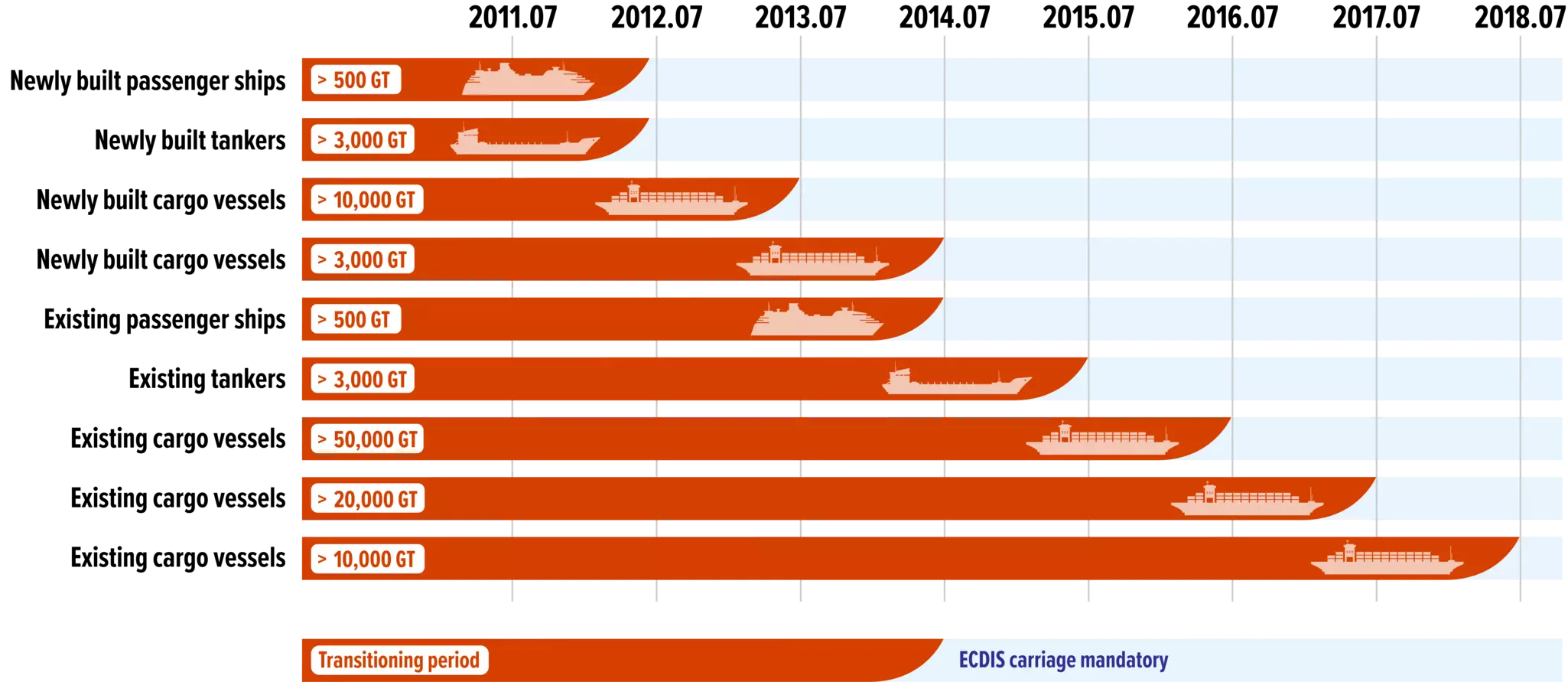
Diagram showing the ECDIS transitioning period.
Prior to implementing ECDIS, high-seas ships and commercial vessels were required to carry up-to-date paper charts and nautical publications for the waters they sailed. While this system had served mariners well for hundreds of years, they also presented many challenges for vessels sailing in the modern world. Printed charts and publications were expensive, difficult to keep updated, and took up a tremendous amount of space onboard. Underway, paper charts only show a vessel’s historical position at the time of a fix, not its real-time position. Navigators always needed to be looking ahead for obstacles and hazards while continuously re-plotting the vessel’s position and offering corrections to the course being steered.
The biggest advantage ECDIS brought to marine navigation was real-time viewing of the vessel’s position. The system continuously updates the ship’s position plot on the electronic chart, showing its relation to the intended course and projected path. ECDIS enhances underway safety by alerting mariners to depth changes, course deviations, critical waypoints, positioning system failures, datum mismatches, and more. ECDIS also reduces crew workload and increases efficiency thanks to digital updates. Now, crews can apply corrections in minutes or seconds that previously took hours to process and apply on paper. Vessels traveling globally benefit from ECDIS and ENCs because their digital nature makes it substantially easier and more economical to maintain a large atlas of charts that are ready to use anytime.
ECDIS navigation systems are required onboard many types of passenger and cargo vessels engaged in international trade and commerce. National rules or regulations may also require the carriage of ECDIS systems onboard vessels in domestic waters. By international regulations, ECDIS is required for:
While the carriage of ECDIS is mandatory for the vessels mentioned above, the operators of many smaller commercial vessels, passenger vessels, and large yachts not otherwise required to fit an ECDIS system have also adopted similar technology for their vessels. Commercial Electronic Charting Systems or ECS are available for these types of vessels that offer many of the safety and efficiency benefits of a full ECDIS system, but in a size and configuration that is more suitable for a compact installation. ECS systems can also be more economical to install because of their smaller display sizes and non-certified status.
Unlike the chartplotter displays found onboard recreational vessels, ECDIS systems are highly regulated in the scope of their features and operating controls. The International Maritime Organization (IMO) created the standards for ECDIS. A branch of the United Nations, the IMO’s mission is to promote safe, efficient, and sustainable shipping through international cooperation. The ECDIS standards ensure that all systems, regardless of manufacturer, offer mariners a familiar user interface, a high level of accuracy, and more efficient navigational operations.


Pathfinder ECDIS is the revolutionary new, user-friendly navigational tool for commercial mariners. IMO certified and designed to be used as both a primary and backup system for all types of vessels.