ChartWorld and Raymarine Commercial unify to form single commercial navigation brand
Learn more
S‑100 is moving from concept to reality, but misconceptions still remain. Discover the truth behind the standard and what it means for the future of maritime navigation.
Wednesday - 01 April 2026
Emma Wise is Director of Cartography at Teledyne. In this article, she examines common misconceptions surrounding S‑100 and clarifies them from a cartographic and implementation perspective:
I for one, have been in the Maritime Industry for 21 years and for as long as I can remember S-100 has been a topic of conversation. For many, many years S-100 has been a hot topic on many people’s lips but it lost momentum somewhere along the way as there seemed to be no progress, no evidence that this is actually going to become a reality. BUT behind the scenes in the maritime standards world there has been a lot of blood, sweat and tears poured into this new generation of maritime data.
So, to remind you all, the S-100 standard is a framework for developing digital products and services for hydrographic, maritime, and GIS communities. It aims to improve the accessibility, compatibility, and usability of hydrographic and marine data, which will support navigation technology and sustainable ocean management. (IHO – 2023) And what does this really mean? In simple terms, I like to refer to S-100 as the Google Maps of the maritime world – layers of geospatial data that provide a real-world picture of the marine environment at any time and can assist you in building your maritime journey.
The good news is that it is actually happening, and in the not-too-distant future. It is real, it is going to be available, and it will provide a huge benefit to the maritime world.
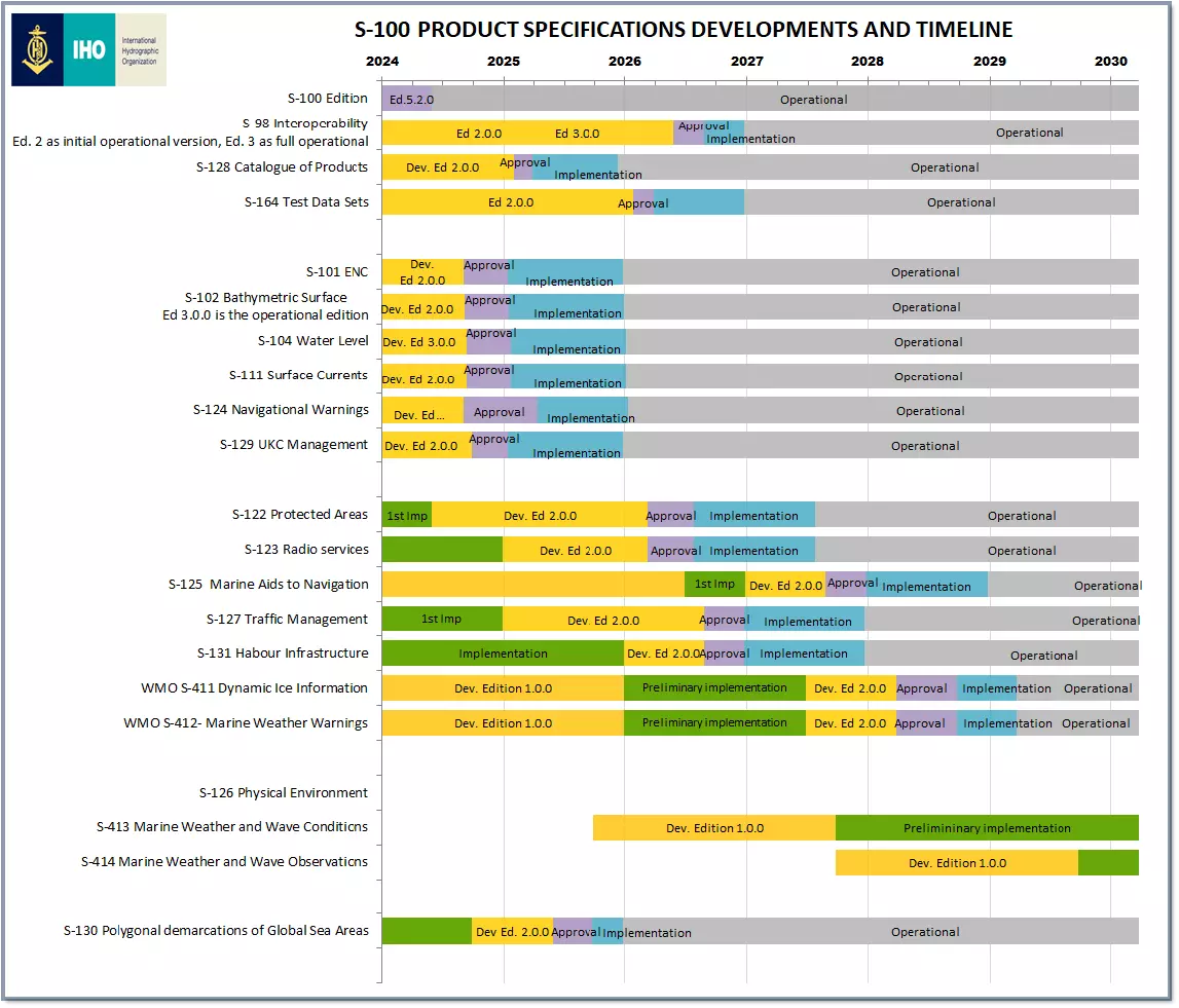
*IHO – S-100 Timelines, updated: July, 2025
From a data production perspective it marks quite a shift, not only in how the data is produced, protected and distributed, but also in who is producing data for the maritime world to utilise on a daily basis for enhancing safety and management at sea. Typically, this space was governed by National Hydrographic Offices (HOs), and whilst HOs remain integral in producing some S-100 data, other S-100 data products will be produced by varying organisations such as waterway authorities, port authorities, meteorological organisations, some industry bodies.
Whilst this presents many challenges in terms of data distribution to the end user, it also provides a huge opportunity in terms of access to data and use of data products that have not been available to the maritime industry before. Exciting right?
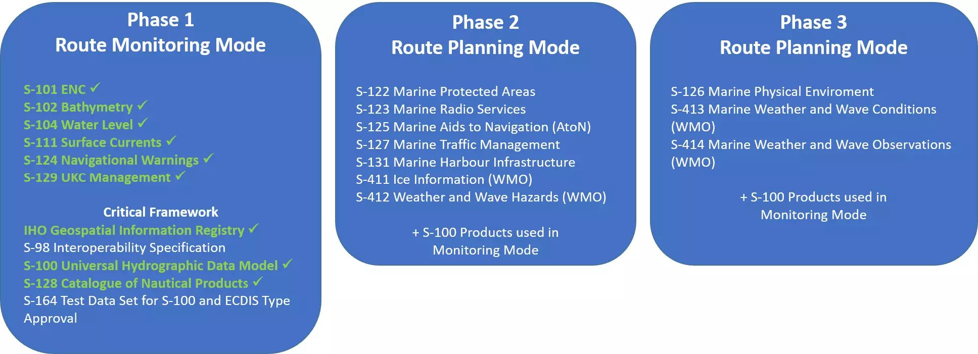
*IHO – S-100 Implementation Priorities, updated: July, 2025
What I also find exciting about all these data products (and many more) is that it opens up a data sharing opportunity and builds an S-100 community. There are many benefits that will be realised by vessels, boats, first responder services, environmental services, marine exploration services, and the list goes on. The standard is built to serve a wide range of stakeholders, from hydrographic offices to independent operators. The improved data structure enhances navigation, safety, and environmental monitoring for all users.
Aside from the rumour that S-100 will never materialise, there are several other rumours that I have gathered and want to try and squash here.
A lot of benefits will be realised over time, and in reality, as you can see from the proposed timelines, not really be in your lap until 2030. But that does not mean you cannot start integrating S-100 into your maritime world now. A few examples, but certainly not exhaustive, are shown in the map from National Oceanographic and Atmospheric Administration (NOAA) in the USA shows coverage of their S-100 products to date: https://nowcoast.noaa.gov/ and in Canada there are S-100 sea trials happening now in the St. Lawrence River https://www.canadas100.ca/
I won't go into details of the perceived benefits S-100 will bring here – these are all well documented, but some headlines, over and above a new generation of electronic charts for mariners, are the integration of these charts with detailed bathymetry, dynamic data, and various layers of marine data to enhance situational awareness and decision making, enabling optimal route planning, better marine protection, and of course improved safety.
Data will be machine readable, facilitating all kinds of autonomous navigation; more economical maritime operations will come from reduced fuel consumption from dynamic real-time current and meteorological data; modern technologies and algorithms utilising augmented reality and artificial intelligence provide intelligence for improving safety at sea and avoiding navigational dangers.
2026 is the year we begin to get our hands on this real, dynamic maritime data and make it a reality. So, let us start getting onboard with this new generation of data; get involved, ask questions, and be it from a commercial or professional perspective, or from a recreational perspective, S-100 is ready to benefit us all.

Emma Wise Director of Cartography at Teledyne Technologies.
Emma has over 20 years of international experience across maritime navigation, hydrography and commercial cartography, having previously held senior leadership roles at ChartWorld International and spent seven years with the United Kingdom Hydrographic Office in Europe and the Asia‑Pacific region.