ChartWorld and Raymarine Commercial unify to form single commercial navigation brand
Learn more
A coordinated industry approach to implementing the IHO S‑100 standard, from data production and distribution to optimized onboard visualisation.
Wednesday - 29 April 2026
The International Hydrographic Organisation (IHO) Standard S-100, known as the Universal Hydrographic Model, along with its derivatives (S-101, S-102, etc.), is set to replace the existing S-57 Electronic Navigational Charts within the next decade. This transition represents a significant change and challenge for stakeholders across the maritime industry, including Hydrographic Offices, IHO, IMO, marine educational institutions, ECDIS manufacturers, and service companies such as data providers.
The primary beneficiaries of the new standard are the end-users, those operating ships or boats. S-100 data is essential for enhancing situational awareness and enabling algorithms that support automatic voyage planning or the operation of unmanned vessels.
Coordinated efforts among all stakeholders are crucial to achieving the main goal of S-100: delivering reliable information to end-users, improving transportation efficiency, and enhancing safety at sea.
Teledyne Technologies and its subsidiaries, Raymarine Commercial, ChartWorld, Teledyne CARIS, and SevenCs, are investing time and resources to ensure a smooth transition for all stakeholders. The implementation of S-100 must prioritise the end-user, whether it's a fisherman operating a 14-foot boat or the captain of a 400-meter container ship.
This article outlines how a coordinated approach to data production, distribution, and visualisation contributes to smarter, safer, and more efficient sea voyages.
Electronic (nautical) data services for the marine industry typically involve the following components:
Without coordination across these steps, the resulting data presentation may cause confusion and frustration rather than improving efficiency and safety. A coordinated approach is therefore essential when offering S-100 data to users.
S-100 itself does not resolve coordination challenges. The well-known “S-100 World” diagram illustrates the complexity of processing hydrographic data from various sources and delivering it efficiently to users.
Similar data across different S-100 products may duplicate or conflict. These conflicts must be resolved during either the data production or presentation phases.
Treating S-100 product selection like the legacy process of choosing charts from paper or electronic catalogues is outdated. Given the wide range of S-100 products, end-users may struggle to identify which ones are relevant to their specific use cases.
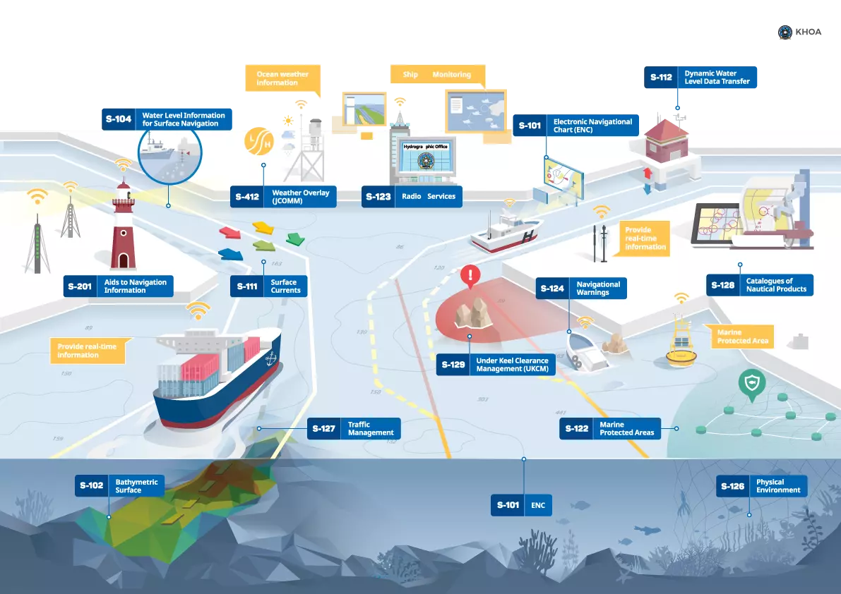
Pic. 1 S-100 World, IHO
The optimal approach is to integrate all components: production, distribution, and visualisation, into a unified system that delivers optimised data for modern visualisation platforms. An integrated solution consists of:
Several technological solutions support centralised hydrographic data storage and bespoke chart production. While no solution currently supports the full range of S-100 products, Teledyne CARIS’s Hydrographic Production Database (HPD) is designed to maintain a consistent database from which S-101 ENC and other S-100 data model products can be generated.
These tools are complemented by Teledyne CARIS’ S-100 Validation and S-100 Data Management System (SDMS), enabling consistent product delivery from Hydrographic Offices to distribution chains.
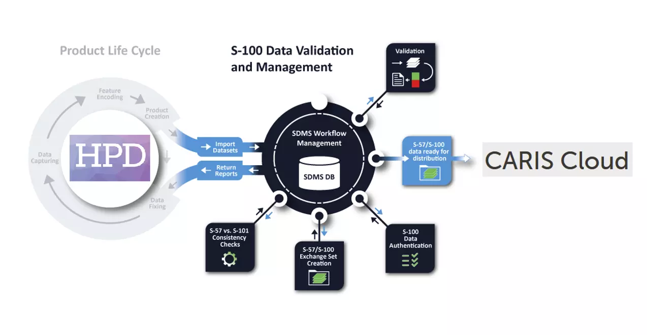
Pic. 2 CARIS data production tools
The existing ENC data distribution model involves a complex chain from Hydrographic Offices to end-users. Stakeholders include Regional ENC Coordinating Centres (RENCs), Value Added Resellers (VARs), and VAR resellers. Sometimes, VARs receive data directly from Hydrographic Offices, or the offices themselves act as VARs, adding complexity.
Despite this, the current system is well-established and generally meets user needs. VARs play a critical role by interacting directly with customers, understanding their requirements, and developing technological solutions for data delivery. Ideally, VARs also manufacture the visualisation systems (ECDIS or ECS), enabling seamless integration between data delivery and user display.
Several National Maritime Administrations have proposed new standards for S-100 data distribution - SECOM and the Maritime Connectivity Platform (MCP), at IMO and IHO. These standards aim to simplify distribution by enabling direct delivery from producers to end-users via harmonised communication protocols.
However, this approach presents challenges:
SECOM and MCP are often referenced in the context of dynamic information, such as S 124 Navigational Warnings. Looking ahead, many S 100 products are also expected to move toward frequent or near real time updates. Experience from the UKHO’s Updates By Event service demonstrates that real time ENC updates are already achievable on existing ECDIS using established distribution mechanisms, highlighting how current approaches can continue to evolve to support the next generation of S 100 data.
VARs have already developed effective methods for ENC data delivery, which can be extended to S-100 products. They request legal frameworks and data access from IHO, Hydrographic Offices, RENCs, and Marine Administrations to support efficient implementation.
VARs’ requirements include:
Deep involvement of VARs will accelerate S-100 adoption across the industry, benefiting both professional users with ECDIS and recreational users with small chart plotters. Safety at sea must not be compromised, S-100 data should be widely accessible.
S-100 represents a major step forward for maritime navigation. This new data model will unlock richer, more actionable navigation data and provide a clearer picture of the maritime environment to support safer, more efficient voyages. As production, distribution, and visualisation come together, mariners will see real operational benefits on the bridge. If you’re planning your transition to S-100, and have questions, contact the ChartWorld experts at Raymarine Commercial to help you turn the promise of S-100 into practical results.